|
Our final posters are due this week with the poster session coming up next week. I sat down with George to analyze the data we have collected over the summer. One of the things that I love most about working in this lab is that all of our data is visual. We made several montages from movies we had taken and kymographs, a type of image we produce that shows spatial position over time in which a spatial axis represents time. 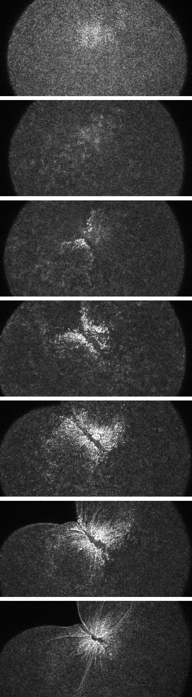 A montage of frames from a movie we took of first cleavage in an early embryo of Clytia gregaria fluorescently tagged for actin. George does a lot of his image processing with ImageJ. It seems like a great program because it is free, open source, and designed for scientific images. The fact that it is open source means that people can actually write plug-ins to do specific things. A lot of scientists use it, so there are heaps of plug-ins for all kinds of processes.
This summer I have been introduced to several free, open source programs that seem to be widely used by the scientific community including Rstudio a free statistics program. Ross Whippo, a PhD student in Arron Galloway’s lab taught a workshop on using R. You can find out more about Ross, and even see the notes from the workshop he taught on this website https://rosswhippo.com/. When we have lunches with researchers one of the questions I have been asking them is “what skills are highly desired in labs?” or “what skills are highly transferable between labs and worth learning?” Over and over they have mentioned learning statistics software, especially R. They have said that many undergrads do not have much statistics and experimental design experience when they apply to graduate school and that developing those skills early is helpful when applying and when getting started actually designing graduate research. Another program I’ve been exposed to here is QGIS. The OIMB library has offered a number of workshops this summer, in addition to a monthly journal club and a book club. A few weeks ago our library hosted Dean Walton, the science reference librarian from the University of Oregon main campus. He taught a short workshop on yet another powerful open source software called QGIS, a rival to ARCGIS the premiere geographic information systems (GIS) software. We took a 1939 aerial photograph of the area where OIMB is and georeferenced the historic photo to current satellite imagery. The first impression was of how much the area had changed, especially with the development of the marina. GIS is a wonderful tool for showing data that has a spatial component to it. This week he will be leading a workshop on photogrammetry for making 3D models of landscapes and specimens which I plan on attending. Everyone is busy working on their posters but that does not mean we did not have enough time to celebrate the Invertebrate Ball last night. Everyone dresses up as their favorite invertebrate and walks down the catwalk. This tradition has been around for a long time and it was really fun.
0 Comments
Leave a Reply. |
AuthorMy name is Philip Aspinall, and I am a student at Sierra College in Grass Valley, California. The first time I peered into a microscope and found an entire, complex, beautiful world below the visible, I was transfixed. I am thankful for George von Dassow and Svetlana Maslakova for allowing me to work in their lab, and to Geroge for his generosity with his time and for being my mentor this summer. Archives
August 2019
Categories |
 RSS Feed